Another Round of Snow in the Forecast
Another round of winter roulette in the forecast for our area.
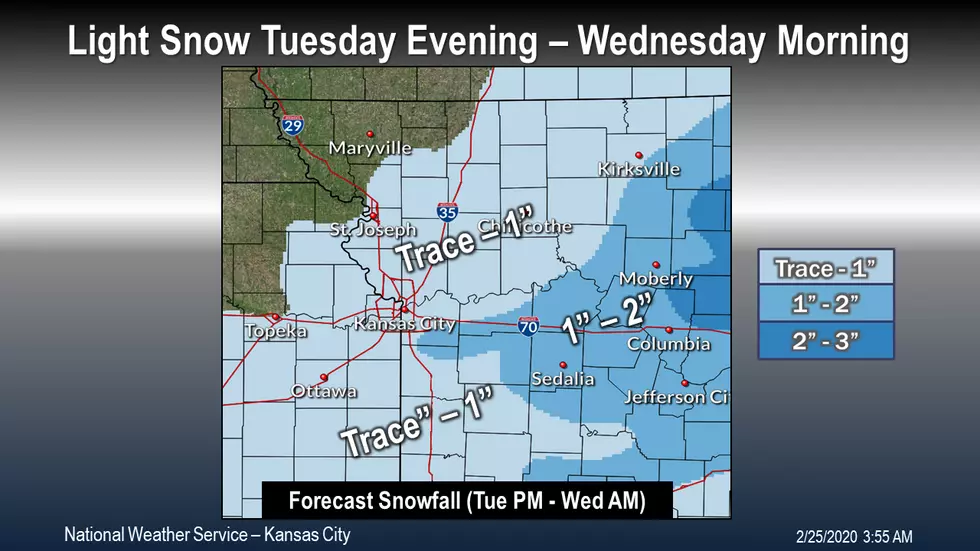
Snow will develop Tuesday evening, ending Wednesday morning. Highest snow totals in central and northeast Missouri.
Here's the forecast for the Sedalia/Whiteman AFB/Warrensburg area according to the National Weather Service:
TuesdayRain and snow likely before noon, then rain likely between noon and 5pm, then rain and snow likely after 5pm. Cloudy, with a high near 38. North wind 9 to 13 mph, with gusts as high as 20 mph. Chance of precipitation is 70%. Little or no snow accumulation expected.Tuesday NightRain and snow likely, becoming all snow after 10pm. Cloudy, with a low around 28. North wind 14 to 17 mph, with gusts as high as 24 mph. Chance of precipitation is 70%. New snow accumulation of 1 to 2 inches possible.WednesdayCloudy, then gradually becoming mostly sunny, with a high near 35. North northwest wind 10 to 17 mph, with gusts as high as 26 mph.Wednesday NightMostly clear, with a low around 19. Northwest wind 5 to 8 mph becoming calm in the evening.ThursdayPartly sunny, with a high near 42.Thursday NightPartly cloudy, with a low around 24.FridayPartly sunny, with a high near 44.Friday NightPartly cloudy, with a low around 24.SaturdaySunny, with a high near 50.Saturday NightMostly clear, with a low around 32.SundayMostly sunny, with a high near 57.Sunday NightMostly cloudy, with a low around 41.MondayA chance of rain. Mostly cloudy, with a high near 58. Chance of precipitation is 40%.
More From KIX 105.7