Storms To The North Could Cause Flooding In Our Area
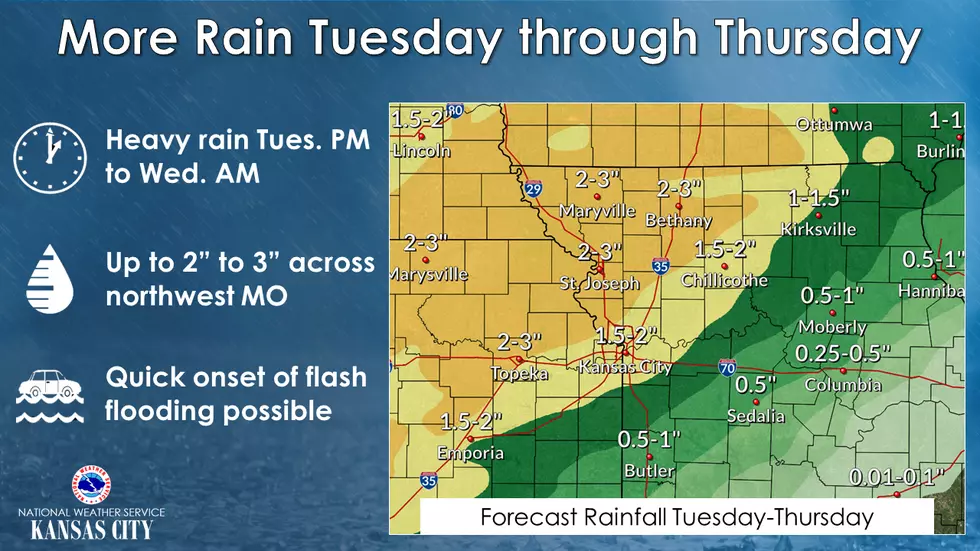
With more rain in the forecast not only in our area but also the northwest portions of Missouri, the after-effects could be more flooding in streams, creeks, and rivers in our area.
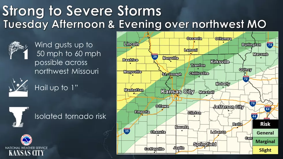
Strong to severe storms are possible across northwest Missouri this afternoon and evening. Main hazards include the potential for strong wind gusts, large hail, along with an isolated tornado risk. Flash flooding concerns will increase overnight into Wednesday over sensitive areas, given the recent heavy rainfall over last weekend.
Here's the forecast for the Warrensburg/Sedalia area from the National Weather Service:
Today
Mostly sunny, with a high near 86. South southwest wind 7 to 15 mph, with gusts as high as 22 mph.
Tonight
Partly cloudy, with a low around 71. South wind 10 to 13 mph.
Wednesday
A chance of showers, mainly after 1pm. Partly sunny, with a high near 81. West southwest wind 8 to 10 mph. Chance of precipitation is 50%. New precipitation amounts of less than a tenth of an inch possible.
Wednesday Night
Showers likely, mainly before 1am. Mostly cloudy, with a low around 57. Southwest wind 6 to 8 mph becoming northwest after midnight. Winds could gust as high as 18 mph. Chance of precipitation is 70%. New precipitation amounts between a half and three quarters of an inch possible.
Thursday
Mostly sunny, with a high near 66. North wind 8 to 10 mph.
Thursday Night
Partly cloudy, with a low around 48.
Friday
Partly sunny, with a high near 66.
Friday Night
A chance of showers after 1am. Mostly cloudy, with a low around 53. Chance of precipitation is 30%.
Saturday
A chance of showers. Mostly cloudy, with a high near 72. Chance of precipitation is 50%.
Saturday Night
A chance of showers before 1am. Mostly cloudy, with a low around 51. Chance of precipitation is 30%.
Sunday
Mostly sunny, with a high near 68.
Sunday Night
Mostly cloudy, with a low around 47.
Monday
Mostly sunny, with a high near 66.
More From KIX 105.7