Rain and Eventually Cooler Temps For The Week
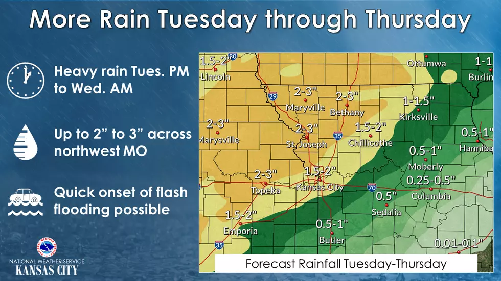
Looking at the weather map provided by the National Weather Service, it looks like the Sedalia/ Warrensburg area is out of the possibility of larger rainfalls. A definite cool down begins on Thursday.
Strong to severe storms and heavy rain are possible this week, beginning Tuesday into Wednesday. Flash flooding is possible over sensitive areas Tuesday and Wednesday across northwest Missouri, where 2 to 3 inches of additional rainfall is expected.
Here's the forecast according to the National Weather Service:
TodayMostly sunny, with a high near 86. South southwest wind 7 to 16 mph, with gusts as high as 24 mph.TonightMostly clear, with a low around 69. South wind 7 to 9 mph.TuesdaySunny, with a high near 85. South southwest wind 7 to 14 mph, with gusts as high as 20 mph.Tuesday NightPartly cloudy, with a low around 69. South wind 6 to 9 mph, with gusts as high as 21 mph.WednesdayA chance of showers after 8am. Partly sunny, with a high near 82. Southwest wind 7 to 10 mph. Chance of precipitation is 50%. New precipitation amounts of less than a tenth of an inch possible.Wednesday NightShowers likely, mainly between 8pm and 2am. Mostly cloudy, with a low around 55. Chance of precipitation is 60%. New precipitation amounts between a quarter and half of an inch possible.ThursdayA chance of showers before 2pm. Partly sunny, with a high near 65. Chance of precipitation is 50%.Thursday NightPartly cloudy, with a low around 47.FridayMostly sunny, with a high near 66.Friday NightPartly cloudy, with a low around 51.SaturdayA chance of showers. Mostly cloudy, with a high near 68. Chance of precipitation is 40%.Saturday NightA chance of showers. Mostly cloudy, with a low around 51. Chance of precipitation is 40%.SundayA chance of showers. Partly sunny, with a high near 67. Chance of precipitation is 30%.
More From KIX 105.7