With the Last Days of April, Greater Chances of Stormy Weather
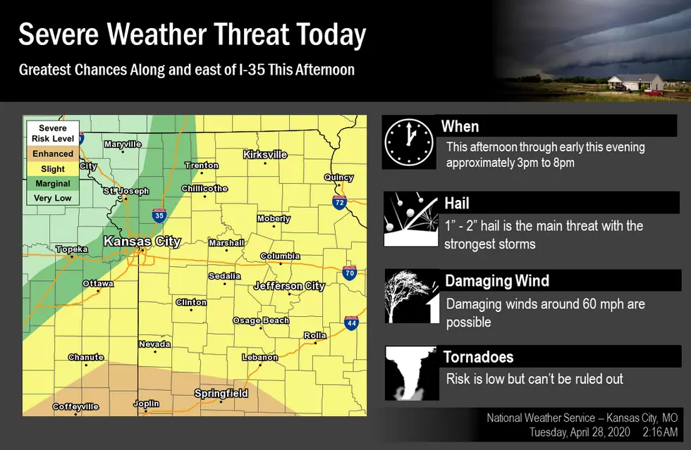
A cold front will move through the area today and help trigger strong to severe thunderstorms. Large hail is the main threat but damaging winds are also possible. The tornado threat is low but can't be ruled out at this time.
Here's the forecast for Sedalia/Whiteman AFB/Warrensburg area according to the National Weather Service in Pleasant Hill:
TodayShowers and thunderstorms, mainly after 4pm. High near 75. South southwest wind 10 to 15 mph, with gusts as high as 25 mph. Chance of precipitation is 80%. New rainfall amounts between a quarter and half of an inch possible.TonightA chance of showers and thunderstorms before 10pm. Cloudy, then gradually becoming partly cloudy, with a low around 51. West wind 8 to 14 mph, with gusts as high as 18 mph. Chance of precipitation is 50%. New precipitation amounts of less than a tenth of an inch, except higher amounts possible in thunderstorms.WednesdayA chance of showers and thunderstorms. Increasing clouds, with a high near 63. Breezy, with a northwest wind 14 to 21 mph, with gusts as high as 33 mph. Chance of precipitation is 40%. New rainfall amounts of less than a tenth of an inch, except higher amounts possible in thunderstorms.Wednesday NightMostly clear, with a low around 45. Northwest wind 7 to 14 mph, with gusts as high as 21 mph.ThursdaySunny, with a high near 70. Northwest wind 6 to 10 mph.Thursday NightMostly clear, with a low around 49.FridayMostly sunny, with a high near 77.Friday NightMostly clear, with a low around 57.SaturdayMostly sunny, with a high near 81.Saturday NightA chance of showers and thunderstorms after 1am. Mostly cloudy, with a low around 60. Chance of precipitation is 30%.SundayA chance of showers and thunderstorms. Mostly cloudy, with a high near 76. Chance of precipitation is 40%.Sunday NightA chance of showers. Mostly cloudy, with a low around 54. Chance of precipitation is 40%.MondayA chance of showers. Partly sunny, with a high near 71. Chance of precipitation is 30%.
More From KIX 105.7