Will It Be Wet This Weekend?
According to the National Weather Service, the weekend shouldn't be a complete washout.
Today will probably be the best day overall as we head into the end of the week, with rain chances returning for the weekend. Don't worry too much about those rain chances on Saturday and Sunday though, we should have more dry time than rain time.
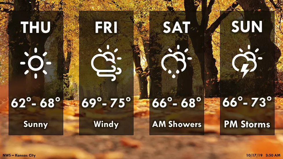
Here's the forecast for the Sedalia/Warrensburg area according to the National Weather Service:
TodaySunny, with a high near 66. South wind 5 to 8 mph.TonightIncreasing clouds, with a low around 46. Southeast wind around 7 mph.FridayMostly cloudy through mid morning, then gradual clearing, with a high near 73. South wind 9 to 17 mph, with gusts as high as 29 mph.Friday NightA slight chance of showers, then a chance of showers and thunderstorms after 1am. Increasing clouds, with a low around 49. South wind 6 to 10 mph, with gusts as high as 20 mph. Chance of precipitation is 50%. New rainfall amounts of less than a tenth of an inch, except higher amounts possible in thunderstorms.SaturdayA chance of showers and thunderstorms before 1pm. Mostly cloudy, then gradually becoming sunny, with a high near 66. Light and variable wind becoming west northwest around 6 mph in the morning. Chance of precipitation is 40%. New rainfall amounts of less than a tenth of an inch, except higher amounts possible in thunderstorms.Saturday NightMostly clear, with a low around 45.SundaySunny, with a high near 71.Sunday NightA chance of showers and thunderstorms. Mostly cloudy, with a low around 49. Chance of precipitation is 40%.MondayA chance of showers and thunderstorms. Mostly sunny, with a high near 63. Chance of precipitation is 40%.Monday NightPartly cloudy, with a low around 42.TuesdaySunny, with a high near 60.Tuesday NightMostly clear, with a low around 41.WednesdaySunny, with a high near 66.
More From KIX 105.7