Weather Conditions to Change Midweek
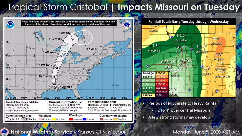
Get ready for a change in the weather as a system moves into our area overnight Monday. The remnants of Tropical Storm Cristobal will bring periods of moderate to heavy rainfall and the chance for a few strong thunderstorms.
Here's the forecast for the Sedalia/Whiteman AFB/Warrensburg area according to the National Weather Service:
TodaySunny, with a high near 89. East southeast wind 5 to 11 mph.TonightA slight chance of showers, then showers and possibly a thunderstorm after 1am. Some of the storms could produce heavy rainfall. Low around 70. East wind 7 to 10 mph, with gusts as high as 20 mph. Chance of precipitation is 90%. New rainfall amounts between three quarters and one inch possible.TuesdayShowers, with thunderstorms also possible after 4pm. Some of the storms could produce heavy rain. High near 87. North wind 9 to 11 mph becoming south southwest in the afternoon. Winds could gust as high as 20 mph. Chance of precipitation is 90%. New rainfall amounts between three quarters and one inch possible.Tuesday NightA chance of showers and thunderstorms. Partly cloudy, with a low around 58. West southwest wind 10 to 14 mph, with gusts as high as 31 mph. Chance of precipitation is 30%. New precipitation amounts of less than a tenth of an inch, except higher amounts possible in thunderstorms.WednesdaySunny, with a high near 75. West wind 14 to 18 mph, with gusts as high as 29 mph.Wednesday NightMostly clear, with a low around 58.ThursdaySunny, with a high near 83.Thursday NightMostly clear, with a low around 61.FridaySunny, with a high near 83.Friday NightMostly clear, with a low around 59.SaturdaySunny, with a high near 79.Saturday NightMostly clear, with a low around 59.SundayMostly sunny, with a high near 83.
More From KIX 105.7