Mid-May Weather Stays Dry A Few Days As It Starts to Warm Up
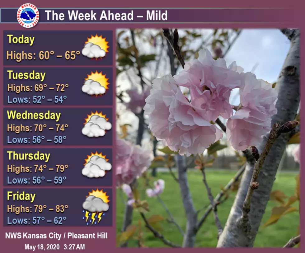
Taking a look at the week head... Mild with temperatures in the 60s and 70s gradually warming into the 80s by the end of the week. An area of low pressure just off to the east of the area will allow for partly to mostly cloudy skies each day over the next several days. Storm chances increase by late week.
Here's the forecast for the Sedalia/Whiteman AFB/Warrensburg area according to the National Weather Service:
TodayCloudy, with a high near 63. Northwest wind 11 to 15 mph, with gusts as high as 22 mph.TonightMostly cloudy, with a low around 54. North northwest wind 8 to 11 mph, with gusts as high as 18 mph.TuesdayMostly cloudy, with a high near 70. North wind around 9 mph.Tuesday NightMostly cloudy, with a low around 57. North northeast wind 3 to 7 mph.WednesdayPartly sunny, with a high near 73. East northeast wind 5 to 8 mph.Wednesday NightPartly cloudy, with a low around 57.ThursdayMostly sunny, with a high near 77.Thursday NightA chance of rain and thunderstorms after 1am. Mostly cloudy, with a low around 60. Chance of precipitation is 30%.FridayA chance of rain and thunderstorms. Partly sunny, with a high near 82. Chance of precipitation is 40%.Friday NightA chance of rain and thunderstorms. Mostly cloudy, with a low around 65. Chance of precipitation is 40%.SaturdayA chance of rain and thunderstorms. Partly sunny, with a high near 85. Chance of precipitation is 40%.Saturday NightA chance of rain and thunderstorms. Partly cloudy, with a low around 67. Chance of precipitation is 30%.SundayRain and thunderstorms likely. Partly sunny, with a high near 85. Chance of precipitation is 60%.
More From KIX 105.7