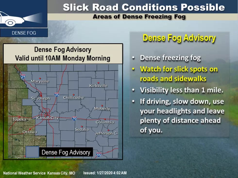
Dense Freezing Fog Advisory in Effect through Mid-Morning
To start off your Monday, the National Weather Service has issued dense freezing fog through 10 AM.
A dense fog advisory is in effect until 10 AM for most of the area. Dense freezing fog may create slick spots on roads and sidewalks. Looking further into the forecast for the period of Tuesday through Sunday, light snow is possible Tuesday morning through Wednesday morning with minor accumulations.
Here's the forecast for the Sedalia/Whiteman AFB/ Warrensburg area according to the National Weather Service:
MondayPatchy fog between 10am and 11am. Widespread dense freezing fog before 10am. Otherwise, mostly cloudy, with a high near 38. Calm wind becoming north 5 to 8 mph in the morning.Monday NightPatchy fog between 8pm and 3am. Otherwise, mostly cloudy, with a low around 27. North northeast wind around 6 mph.TuesdayA slight chance of snow after noon. Mostly cloudy, with a high near 35. North northeast wind 6 to 8 mph. Chance of precipitation is 20%.Tuesday NightA chance of snow. Cloudy, with a low around 25. North northeast wind 3 to 5 mph. Chance of precipitation is 40%.WednesdayMostly cloudy, with a high near 35.Wednesday NightMostly cloudy, with a low around 24.ThursdayMostly cloudy, with a high near 39.Thursday NightMostly cloudy, with a low around 28.FridayPartly sunny, with a high near 43.Friday NightMostly cloudy, with a low around 31.SaturdayMostly sunny, with a high near 47.Saturday NightPartly cloudy, with a low around 34.SundaySunny, with a high near 54.
More From KIX 105.7