Bye, Bye 60’s…Back To Reality!
We hope you enjoyed your warm Thursday since it's time to get back to the reality that we're in November and not late September in Missouri.
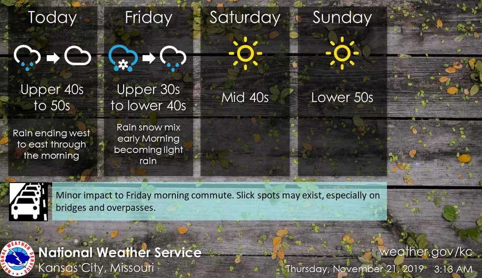
Between the Sedalia/Warrensburg area and Kansas CIty, a light wintry mix of snow and rain is expected late tonight and may result in some slick spots on area roadways for the Friday morning commute.
Here's the forecast for the Sedalia/Warrenburg area according to the National Weather Service:
Thursday-Rain likely and possibly a thunderstorm before 7am, then a chance of rain between 7am and 9am. Mostly cloudy, with a temperature falling to around 47 by 5pm. Southwest wind 10 to 15 mph becoming north northwest in the afternoon. Winds could gust as high as 31 mph. Chance of precipitation is 60%. New precipitation amounts of less than a tenth of an inch, except higher amounts possible in thunderstorms.
Thursday Night-A slight chance of rain between midnight and 1am. Cloudy during the early evening, then gradual clearing, with a low around 30. North wind 7 to 9 mph. Chance of precipitation is 20%.
Friday-A chance of rain after noon. Increasing clouds, with a high near 41. North northeast wind 5 to 8 mph. Chance of precipitation is 50%. New precipitation amounts of less than a tenth of an inch possible.
Friday Night-A chance of rain, mixing with snow after 11pm, then gradually ending. Cloudy, with a low around 30. Light north wind. Chance of precipitation is 40%.
Saturday-Mostly sunny, with a high near 46.
Saturday Night-Mostly clear, with a low around 30.
Sunday-Mostly sunny, with a high near 54.
Sunday Night-Mostly clear, with a low around 35.
Monday-Mostly sunny, with a high near 57.
Monday Night-A chance of rain. Mostly cloudy, with a low around 39. Chance of precipitation is 30%.
Tuesday-A chance of rain. Mostly cloudy, with a high near 52. Chance of precipitation is 40%.
Tuesday Night-A chance of rain. Mostly cloudy, with a low around 30. Chance of precipitation is 30%.
Wednesday-Mostly sunny, with a high near 47.
More From KIX 105.7