Wait…Isn’t This Winter?
Looking at the forecast for the next week makes me believe that something is going on with Mother Nature.
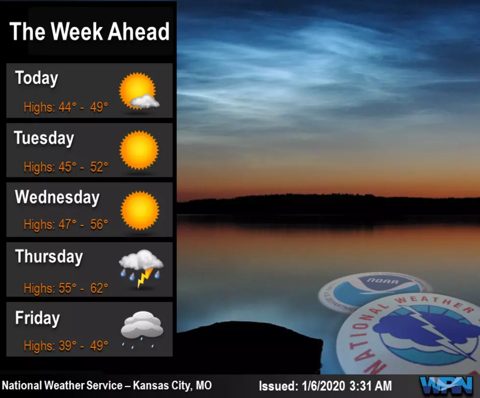
Mild temperatures and dry conditions will continue through midweek. Thursday there will be the chance for showers as well as few thunderstorms. Rain is expected to continue into Friday with a change over to snow possible Friday night.
Here's the forecast according for the Sedalia/Warrensburg area according to the National Weather Service:
TodayPartly sunny, with a high near 47. Calm wind becoming south around 6 mph.TonightMostly cloudy during the early evening, then gradual clearing, with a low around 29. Light and variable wind becoming west 5 to 9 mph in the evening.TuesdaySunny, with a high near 49. West wind 7 to 10 mph.Tuesday NightMostly clear, with a low around 29. Southwest wind around 6 mph becoming south southeast after midnight.WednesdaySunny, with a high near 54. Southeast wind 5 to 11 mph, with gusts as high as 21 mph.Wednesday NightMostly cloudy, with a low around 44.ThursdayShowers likely, mainly after noon. Cloudy, with a high near 62. Chance of precipitation is 60%.Thursday NightRain likely, mainly before midnight. Mostly cloudy, with a low around 38. Chance of precipitation is 60%.FridayA chance of rain after noon. Mostly cloudy, with a high near 49. Chance of precipitation is 50%.Friday NightRain likely before 11pm, then rain and snow likely between 11pm and 1am, then a chance of snow after 1am. Mostly cloudy, with a low around 27. Chance of precipitation is 60%.SaturdayA chance of rain and snow. Mostly sunny, with a high near 39. Chance of precipitation is 40%.Saturday NightMostly clear, with a low around 25.SundayMostly sunny, with a high near 48.
More From KIX 105.7