Storms Back In The Forecast Thursday Afternoon/Evening?
Just when we were settled into some great early fall-like weather, Mother Nature decides she wants to possibly throw a wrench into things.
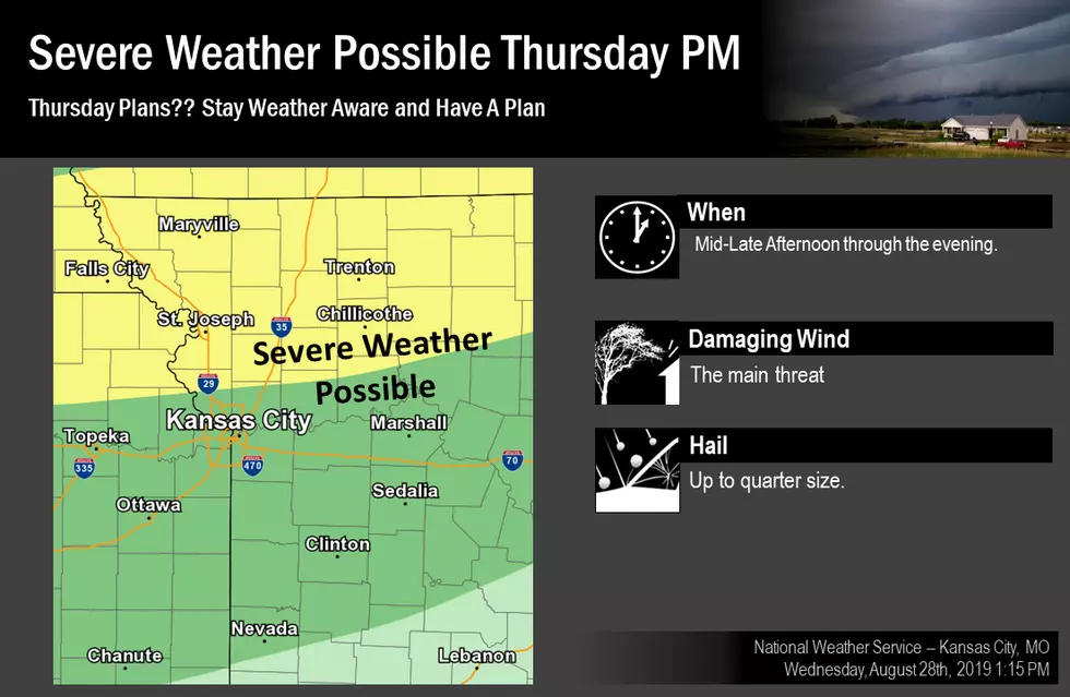
According to the National Weather Service (NWS) in Pleasant Hill, another round of strong to severe storms possible Thursday afternoon and evening. Here's the latest forecast through the Labor Day weekend for our area from the NWS:
TodaySunny, with a high near 85. Southwest wind 7 to 14 mph, with gusts as high as 22 mph.TonightShowers and thunderstorms likely, mainly after 1am. Increasing clouds, with a low around 67. South southwest wind 6 to 8 mph becoming southeast after midnight. Chance of precipitation is 70%. New rainfall amounts between a half and three quarters of an inch possible.FridayShowers and thunderstorms likely, mainly before 1pm. Cloudy, with a high near 77. North wind 6 to 8 mph becoming east northeast in the afternoon. Chance of precipitation is 70%. New rainfall amounts between a quarter and half of an inch possible.Friday NightA chance of showers and thunderstorms. Mostly cloudy, with a low around 66. Light east wind. Chance of precipitation is 50%. New rainfall amounts between a tenth and quarter of an inch, except higher amounts possible in thunderstorms.SaturdayShowers and thunderstorms likely, mainly before 1pm. Mostly cloudy, with a high near 76. Calm wind becoming south around 6 mph in the morning. Chance of precipitation is 60%. New rainfall amounts between three quarters and one inch possible.Saturday NightA chance of showers and thunderstorms. Mostly cloudy, with a low around 66. Chance of precipitation is 40%. New rainfall amounts of less than a tenth of an inch, except higher amounts possible in thunderstorms.SundayPartly sunny, with a high near 77.Sunday NightPartly cloudy, with a low around 64.Labor DayMostly sunny, with a high near 82.
More From KIX 105.7