Milk, Bread, and Toilet Paper…Oh My!
Whenever we get the forecast for a patch of snow or winter-like weather coming through the region, we go into panic mode and run to the grocery store. For some reason we feel like it's the last time we'll be able to go buy the necessities to weather the storm (no pun intended) for at least a week or two.
Well, we do have in the forecast the chance of our first snowfall in the new year. Rain, ice, and snow are all expected. A little of this and a little of that. Let's hope there's a little less ice when all this comes through the area.
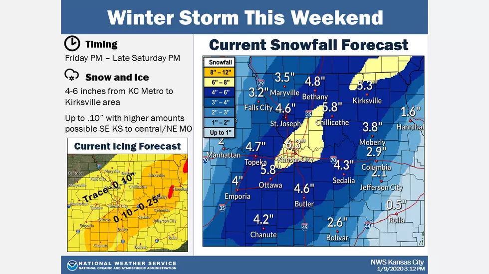
A winter storm will occur this weekend and will bring a multitude of hazards. From Friday night through Saturday Friday, freezing rain amounts could be as high as a couple tenths of an inch. The freezing rain is expected change to snow from north to south late Friday night into Saturday with the heaviest snow amounts through late Saturday night from KC to northeastern Missouri.
Here's the forecast for the Sedalia/Warrensburg area according to the National Weather Service:
FridayRain, mainly after 2pm. The rain could be heavy at times. High near 54. Northeast wind 5 to 10 mph. Chance of precipitation is 100%. New precipitation amounts between three quarters and one inch possible.Friday NightRain and freezing rain, possibly mixed with sleet before 4am, then freezing rain and sleet likely. The rain could be heavy at times. Low around 25. Blustery, with a north wind 14 to 23 mph, with gusts as high as 32 mph. Chance of precipitation is 100%. New ice accumulation of around a 0.1 of an inch possible. New sleet accumulation of less than a half inch possible.SaturdaySnow and sleet, possibly mixed with freezing rain before 10am, then snow, possibly mixed with sleet between 10am and 11am, then snow after 11am. Patchy blowing snow between noon and 1pm. High near 26. North wind 13 to 18 mph, with gusts as high as 28 mph. Chance of precipitation is 90%. New ice accumulation of less than a 0.1 of an inch possible. New snow and sleet accumulation of 2 to 4 inches possible.Saturday NightSnow and freezing rain before 11pm, then a slight chance of snow between 11pm and 1am. Low around 12. Northwest wind 6 to 11 mph becoming light and variable after midnight. Chance of precipitation is 90%. New snow accumulation of less than a half inch possible.SundayMostly sunny, with a high near 39.Sunday NightPartly cloudy, with a low around 20.MondayMostly sunny, with a high near 46.Monday NightMostly cloudy, with a low around 35.TuesdayMostly sunny, with a high near 50.Tuesday NightPartly cloudy, with a low around 27.WednesdayPartly sunny, with a high near 42.Wednesday NightA chance of snow. Partly cloudy, with a low around 15. Chance of precipitation is 30%.ThursdayA chance of snow. Mostly sunny, with a high near 31. Chance of precipitation is 30%.
More From KIX 105.7